 |
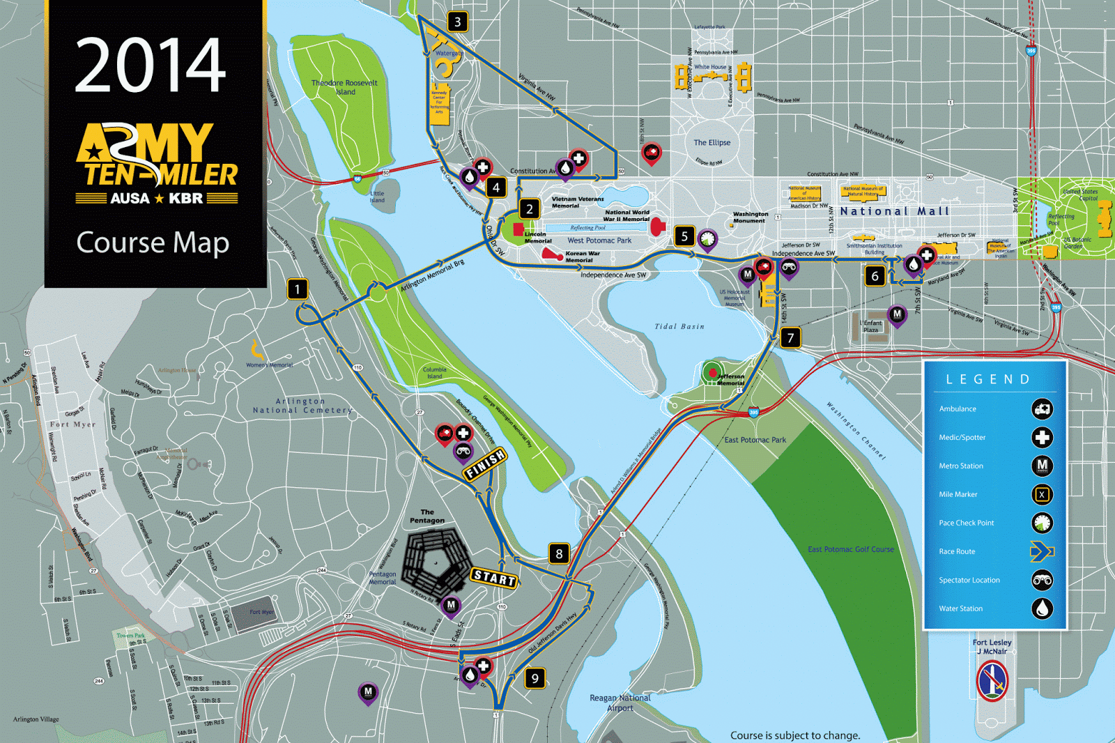
| The official course map |
Here is my general assessment of the course. I couldn't find an elevation guide anywhere, so I'm guessing a bit on where the hills are based on a very imprecise map I made on Garmin. I know it is imprecise because it mapped my 10-mile race as 11.2 miles. Let's hope I don't run that much on race day!
- Mile 1 - start by the Pentagon, run through Arlington on 110.
- Mile 2 - past Arlington National Cemetery, across the Memorial Bridge (small hill) and around the Lincoln Memorial. Entertainment: U.S. Army Band!
- Mile 3 - along Constitution and up Virginia Ave to the Watergate (steady hill here). Water stop in the beginning of the mile.
- Mile 4 - around the Watergate and onto Rock Creek Parkway, past the Kennedy Center, along the Potomac River. Water stop towards the end of the mile. Have GU before water stop! Entertainment: U.S. Army Band (again)!
- Mile 5 - along Ohio Drive and onto Independence Avenue. Views of Lincoln Memorial, Korean War Memorial, and Jefferson Memorial, as well as the Reflecting Pool and Tidal Basin. Hill somewhere on Independence, perhaps just past pace check clock at mile marker 5.
- Mile 6 - More Independence Ave along the Mall (hello, Washington Monument!). At 7th Street, go around the block (water stop) to run back along Independence. Entertainment: Paul VI High School Band!
- Mile 7 - More Independence Ave and a turn onto 14th Street. Have GU and drink from hydration belt before the bridge.
- Mile 8 - More 14th Street past the Jefferson Memorial and then across the 14th Street Bridge onto 395 (hill to get up highway ramp). Entertainment: Sandy Point Band!
- Mile 9 - More 395, Army Navy Drive, Old Jefferson Davis Highway, water stop towards the end of the mile. Looks like a bit of a rough stretch scenically.
- Mile 10 - More Old Jefferson Davis Highway, onto Boundary Channel Drive and up to the finish at the Pentagon!
UPDATED! The awesome Tai Fung (I can always count on his twitter feed for entertainment - seriously, you should follow him!) shared his elevation map from last year. The course varies slightly in two places this year (1) in mile 3 the turn towards Virginia Avenue occurs a block earlier (effectively shifting much of the picture below to the left), and (2) the exit from 395 is on the opposite side changing the approach to the finish line over the last mile. Thank you Tai!!
So that's what I know (or at least what I think I know). I would welcome any advice, corrections, and/or additions in the comments since I don't quite know what I'm getting into with this one. I still need to consider additional logistics, like exactly how to get there in the morning, how long security will take, and what to do about the fact that none of the dozens of people I know who are running are in the same corral as me. I have a fun week of prepping ahead of me!
 |
| 2013 Course Elevation Map, courtesy of Tai Fung |
So that's what I know (or at least what I think I know). I would welcome any advice, corrections, and/or additions in the comments since I don't quite know what I'm getting into with this one. I still need to consider additional logistics, like exactly how to get there in the morning, how long security will take, and what to do about the fact that none of the dozens of people I know who are running are in the same corral as me. I have a fun week of prepping ahead of me!

Good luck Kim! Use a Smartcard if you can if you use the metro (it will be crowded). I would leave a little more time for security and the mini walk it takes to get to the starting corrals.
ReplyDeleteThank you for the tips Jennifer! I will definitely have my Smartcard with me. And plan that extra time. I think this will be more people than I have ever seen at a race!
DeleteSee you there! Don't worry about the course just do it! It's very motivating and pretty flat except for the end. The last mile always gets me
ReplyDeleteThanks for the perspective and zen approach, Deborah! Love it.
DeleteThis is really helpful. Thanks!
ReplyDeleteI'm so glad it's helpful. Good luck tomorrow!
Delete